
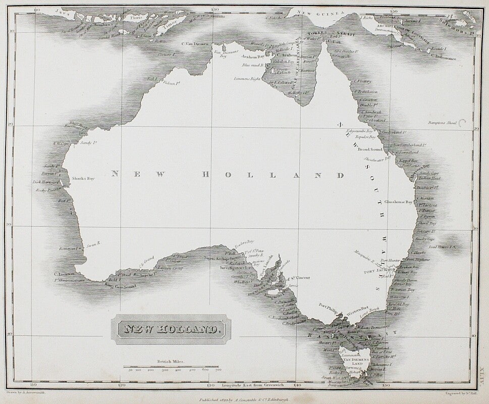
Arrowsmith, Aaron
A new general atlas
Edinburgh London, A. Constable & Co and Longman & Co 1823
"Constructed from the latest Authorities by A. Arrowsmith, Hydrographer to the King, Exhibiting the Boundaries and Divisions, also the Chains of Mountains and other Geographical Features of all the Known Countries in the World. Comprehended in fifty three maps from original drawings”.
4to 30x24 cm, nice recent binding with original label. 53 maps with all tissue guards present. Minor light foxing, mainly -as usual- the tissue guards. Stain in the border of the map of Hindoostan. All maps engraved by Sidney Hall. This scarce edition was published in the year of his death. Arrowsmith was to establish himself as “easily the foremost cartographer of his time”. In 1810 he became Hydrographer to the Prince of Wales and, in 1820, Hydrographer to the King.
€ 980


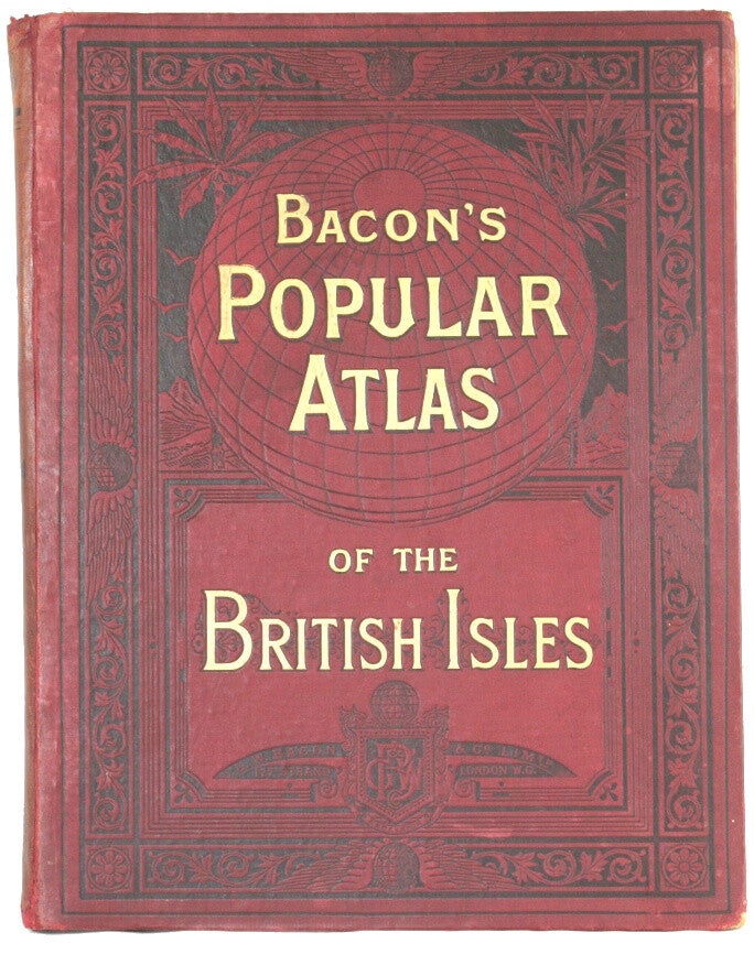
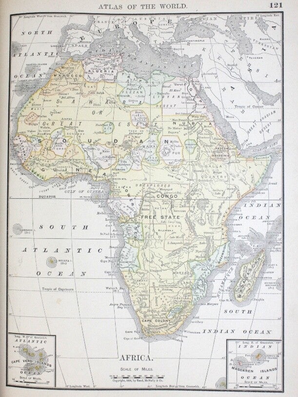
Bacon, G. W.
Bacon's popular atlas of the British isles / Commercial and library atlas of the British isles
G. W. Bacon, London 1898
"from the ordnance survey with index-gazetteer, also copious letterpress descriptions, tables of population, etc".
Folio 35x26 cm, Large red cloth hardback book, traces of use and age. Contents 65 maps, flags of all nations, diagrams of population, diagrams of trade, key map of England and Wales, key map of Scotland, key map of Ireland. Contents page with repaired tear, small repairs on folds. All maps are in very good condition. Slight foxing to blank pages inside cover. Uncommon edition.
€ 390


Bartholomew, John
Philips' Handy General Atlas of the World
London, George Philip and Son 1879
"A Comprehensive Series of Maps illustrating Modern, Historical and Physical Geography. With a complete Consulting Index. New edition, revised and corrected to the present time."
Large 4to 34x24 cm, rebound using the original embossed boards. With 39 maps (most of which are double page) and a 83 page index. The maps include 3 double page maps of the Australian area (Oceania; Australia; New South Wales, Victoria & Part of South Australia) and single-page maps of Queensland and New Zealand (the latter map having an inset of Tasmania). For North America, the 3 maps are of North America; Dominion of Canada & Northern United States; United States. These are all double page. The contents are very good with light scattered foxing. Uncommon.
€ 290


Blackie, W. G.
The comprehensive atlas & geography of the world
Blackie & Son, London 1883
Very thick 4to 39x33 cm, half calf with spine in six compartments, cloth on boards worn. With 67 colour maps, many double page plus 292 pages of geography with 10 superb colour plates of races of the world and their costumes and a pronouncing vocabulary of place names. Text, illustrations and maps very good, some light traces of use.
When published, it was considered one of the most beautiful atlases of it's time.
€ 480


Delamarche, F.
Atlas de géographie ancienne et moderne
Paris, F. Delamarche 1824
"adopté par le conseil royal de l'instruction publique"
Folio 33 x 26 cm, leather spine, marbled boards with wear and repairs. 34 in stead of 33 double page (or even larger folded) outline coloured maps (extra: Carte du monde connu des anciens). Contents generally very good and clean.
Félix Delamarche, successor of Robert de Vaugondy, was a French geographer and engineer who flourished during the 18th century and early 19th century. Delamarche created the Atlas de la géographie ancienne et moderne in 1820. The atlas was reprinted during the 19th century. It was utilized by the Ecole Spéciale Militaire de Saint-Cyr.
€ 480


Drioux / Leroy
Atlas Universel Et Classique De Geographie Ancienne, Romaine, Du Moyen Age, Moderne Et Contemporaine
Paris, librairie classique d'Eugene Belin 1874
Folio 33x27 cm, leather spine with gilt lettering, marbled boards with soiling, rubbing of boards and spine. Lacks small part right under front board. Nouvelle édition with 76 maps, most are double-page.
Drioux was the "star author" of the publishers Belin. As a geographer Drioux worked primarily with cartographer Charles Leroy.
€ 220


Dussieux, L.
Atlas de géographie
Paris, Louis Lecoffre ~ 1871
"Physique, Politique, Historique, Commerciale et Agricole" "nr.2" "Atlas complet de Geographie Ancienne, Du Moyen Age et Moderne. Nouvelle Edition, contenant 86 cartes coloriées a teintes plates".
Folio 33 x23 cm, leather spine with gilt lettering, marbled boards with soiling, rubbing of boards and spine. With 86 maps among which a large folding map of France, contents good, slightly foxed.
Title page has no date, but in the maps Alsace-Lorraine is still french, while the german maps show (already) an empire. First edition was in 1846.
€ 220


Feuille, Paul de la
Les tablettes guerrieres, ou cartes choisis pour le commodité des officiers et des voyageurs
Amsterdam, chez Paul de la Feuille 1709
Narrow 8vo (8x20cm, maps ca 20x27cm), contemporary full calf, spine-ends slightly damaged, leather covers have some wormholes. 16 pages (Abregé de la geographie), 16 pages (102 military rules!), 33 folding engraved maps: worldmap, Europe, Africa, Asia, North America, South America, 26 maps of parts of Europe (all but one with borderstrips depicting views, plans and coats of arms) and 1 plate with military architecture. Neat restorations on folds.
A scarce military pocket atlas, used during the War of Succession, with beautiful maps, among which America with California as an island. Also issued in Dutch (Oorlogs-Toneel, of uitgesochte kaarten, tot gemak der officieren en reisigers) and English (Military tablettes, containing a choice of maps, for the use of officers and travellers). First edition in 1706 and re-issued 1709-1729. The buyer could make up his own atlas with a minimum of 30 maps, and maximum almost 100.
€ 2.500


Gordon
Geography anatomiz'd or the Geographical Grammar
London, J. J. and P. Knapton 1735 14th edition
8vo 20x13 cm full calf, worn and hinges strengthened. Half titles, title page, 6 page Epistle Dedicatory, 12 page preface, contents, 416 pages text, and 16 pages (last leaf in copy) table of latitudes/longitudes, no free end papers. Includes 17 folding maps by the famous Senex. Maps (2 with California as an island) measure 20x22 cm except the world map which measures 20x31 cm. Good copy.
€ 550


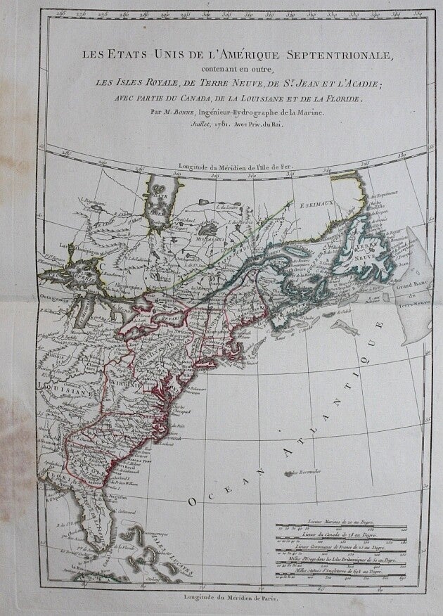
Grenet, Abbé (M. Bonne)
Atlas Portatif, a l'usage des colleges
Paris, ~1782
4to, original green vellum (stain). Double page decorative frontispiece and 84 (!) outline coloured double page maps of the world made by Bonne. Some maps have a stain in the undermargin (see picture). Nevertheless, a nice copy of a scarce atlas.
Rigobert Bonne (1727–1794) was a French cartographer, widely considered to be one of the most important cartographers of the late 18th century. Bonne’s work represents an important step in the evolution of the cartographic ideology away from the decorative work of the 17th and early 18th century towards a more detail oriented and practical aesthetic.
€ 2.600


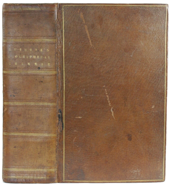
Guthrie, William
A new geographical, historical and commercial Grammar
London, Dilly 1794 14th edition
"and present state of the several kingdoms of the world" "To which are added, I. A geographical index. II. A table of the coins of all nations. III. A chronological table of remarkable events from the creation to the present time".
Thick 8vo contemporary full calf with normal wear, gilt, hinges strenghtened. 965 pages with information about countries, explorations etc etc and 24 maps by Russell and an engraving of the armillary sphere. Small tear and 2 tiny stains in world map (40x21 cm), repaired tear on fold in Europe-map. Some misfoldings and traces of use but overall nice and clean.
€ 490


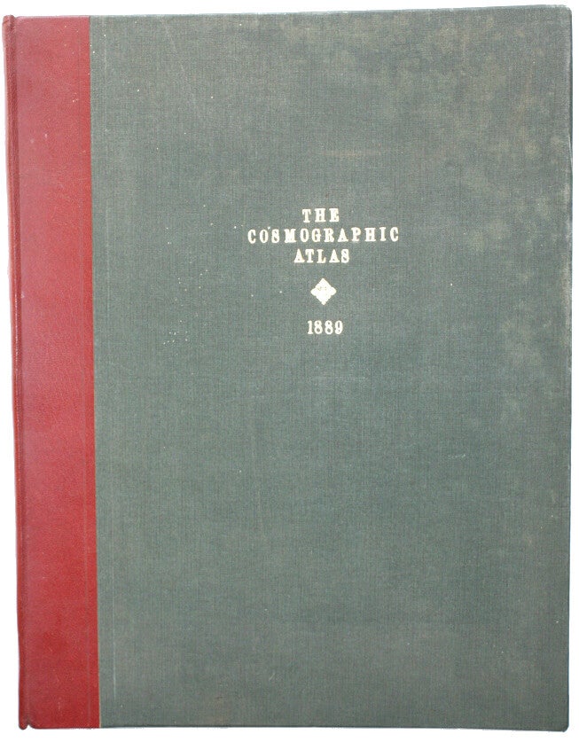
Johnston, W. & A. K.
The Cosmographic Atlas
Edinburgh and London, W & A K Johnston 1889
"of Political, Historical, Classical, Physical and Scriptural Geography and Astronomy with indices and Descriptive Letterpress".
Large folio 48x38 cm, rebound in quarter morocco and green (bowed) boards. 60 maps coloured in outline together with 6 full colour astronomical 'maps'. Internally good with ageing and a little soiling, world maps with repaired tear. Good used copy.
Johnston combined cartography with a painstaking and scholarly approach to map production. He went on to establish a reputation for scope and accuracy. Thematic atlases became the hallmark of the company he had founded and W. & A. K. Johnston were appointed engravers to King William IV in 1834.
€ 380


Johnston, W & A. K.
The World-wide Atlas of modern geography
Edinburgh-London, W. & A.K. Johnston 1899 fourth edition
"political and physical. Containing one hundred and twenty-eight plates and complete index. With an Introduction by J. Scott Keltie."
Large 4to 32x26 cm, embossed cover in excellent condition. A (value for money) beautiful turn-of-the-century atlas with 128 detailed (regional) maps and town plans, flags and timetable. Hard to find in this almost fine condition.
€ 170


Johnston, W & A. K.
The Royal Atlas of Modern Geography
Edinburgh and London, W. Blackwood & Sons 1869
Elephant folio 50x33 cm, original half leather in very good condition. 48 large engraved maps with outline colouring, clean except for a little scattered foxing. Bookplate of John Madden of Hilton Park.
In 1861 Johnston published the first edition of the Royal Atlas of Modern Geography with 48 maps. By 1914 the atlas had gone through 12 editions and morphed into the Johnston's Handy Royal Atlas of Modern Geography with 61 colour lithographed maps and an index of 84 pages. While the Bartholomew's Citizen's Atlas sold more copies, being half the price, the Royal Altlas became the standard library atlas throughout the British Empire. This really is a Royal atlas!
€ 650


Lesage (le Sage - comte De Las Cases)
Atlas historique, généalogique, chronologique et géographique... avec des augmentations
Bruxelles, P. J. De Mat 1827
Elephant folio 60x40 cm, boards and spine (heavily) worn, but binding is sound. With half-title, tille-page, a decorative illustrated engraved plate with a genealogy and history of Napoleon’s family, 36 numbered double-page spreads with letterpress text (18 containing 24 engraved hand coloured maps and 17 containing genealogical and historical tables). The beautiful maps are in excellent condition. With the prospectus of the publisher.
Note this is the scarcer Bruxelles-edition!
€ 550


Lesage (le Sage - comte De Las Cases)
Atlas historique, généalogique, chronologique et géographique
Paris, Leclère 1829
Elephant folio 55x39 cm, red morocco spine, marbled boards worn. (34+2) 36 numbered double-page pages with letterpress text and maps. The beautiful maps are complete and in excellent condition. Double textpages 10 and half of 11 missing.
€ 250


Malte-Brun
Atlas du Précis De La Geographie Universelle Ou Description De Toutes Les Parties Du Monde Sur Un Plan Nouveau
Paris, Bureau des publications illustrées 1846
Folio 40x30 cm, cloth with original paper covered boards with wear. 86 plates with 72 (14 double) maps (full- outline- non-coloured). Light soiling, maps in nice condition.
Showing the first railways, detailed maps of Africa and Texas apart. His major work is this famous Précis published from 1810 onwards. This work, whose last volume appeared in 1829 after the death of Malta-Brun, was a considerable success if one judges by the number of re-editions and increases until the Geography of Reclus dethroned it after 1860.
€ 630


Martineau, M. A.
Nouvel atlas illustré
Paris, Direction et administration 1891
"Géographie universelle comprenant la géographie, l'histoire, l'administration, la statistique, etc".
Folio 41x31 cm, leather spine with blindstamped boards, traces of use. About 150 pages of text, 62 double page maps, each with a beautiful steel engraving of a city-view etc. A nice and clean atlas in very good condition.
Textpages contain a lot of interesting information of the countries of the world.
€ 390


Migeon
Géographie universelle
Paris, 1884
bound with:
La France et ses colonies atlas illustré
Paris, 1883
Small folio 35x27 cm, gilt stamped boards and spine, traces of use and edges bumped and frayed. 43 coloured double page maps by Vuillemin and others, each with accompanying double page leaf of text. Traces of use.
La France et ses colonies atlas illustré: Idem, with 107 (in stead of 105) maps by Vuillemin. Scarce as a uniform set.
€ 650 set


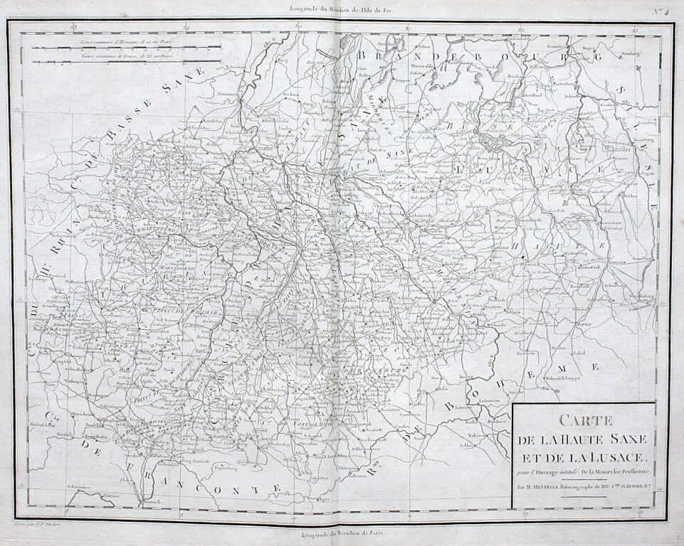
Mirabeau, H. G. Riquetti Comte de
Atlas de la monarchie Prussienne
London, 1788
Folio 40x27 cm, covers and spine worn, binding tight. 10 engraved double page maps (Tardieu after Mentelle) and 93 engraved (military) plates (some folding).
Mirabeau (1749 - 1791) was a French writer, popular orator and statesman. During the French Revolution, he was a moderate, favored a constitutional monarchy built on the model of Great Britain, and conducted secret negotiations with the king in order to reconcile the monarchy and the revolution, an effort that failed. After a preliminary tour to Berlin at the beginning of 1786 he was despatched in July 1786 on a secret mission to the court of Prussia, from which he returned in January 1787. During his journey he had made the acquaintance of Jakob Mauvillon (1743-1794), whom he found possessed of a great number of facts and statistics with regard to Prussia; these he made use of in a great work on Prussia of which this is the atlas volume. His De la monarchie Prussienne sous Frédéric le Grand (London, 1788) gave him a general reputation for historical learning.
€ 630

Monin, E. V.
Atlas universel de Geographie ancienne et moderne en 42 cartes
Paris, Jacques Lecoffre ~1840
Large 4to 35x25 cm, cloth spine with marbled paper boards, hinges cracked, some soiling.
€ 320


Rand McNally
Standard atlas of the world
Chicago, Rand Mc Nally and company 1888
Folio 36x28 cm, gilt decorative embossed cloth-covered boards worn, binding partly broken but holding firm enough. 192 pages full of information with more than 120 full page and double page colour maps (many of the USA), colour plates, black and white engravings and colour diagrams. What made Rand McNally unique at the time, and gave them an important advantage in the map publishing business, was that instead of using steel or copper engraving techniques, they adopted a wax engraving method called relief line engraving.
€ 290


Rand McNally
General atlas of the world
Chicago, Continental publishing company 1889
"Containing Large scale maps of every State, Territory and Country in the World, with carefully prepared Historical and Discriptive Sketch of each. Together with an alphabetically arranged list of every Railroad Station in the U.S., Canada and Mexico, Principal Cities, Lakes, Rivers, Islands and Mountain Peaks of the Entire Globe and other Statistical Tables on all Geographical Subjects"
4to 31x23 cm, decorated cloth with traces of use. 216 pages with 95 (many of the USA) coloured maps in very good condition.
€ 240

Reclus, Elysee
Nouvelle Geographie Universelle : L'Europe du Nord-Ouest
Paris, Hachette 1879
4to 27x20 cm, rich decorated boards with gilt edges signed Magnier. This volume includes Belgium, Netherlands and Great Britain. Monumental geography book with 970 pages, 6 coloured maps, 81 views and 205 small maps and city plans in the text! Apart from the usual foxing an excellent copy.
€ 90


Sanson
Atlas nouveau du Voyageur pour les dix-sept Provinces des Pais-Bas
Amsterdam, Pierre Mortier ~1700
"avec la description géographique & d'une table pour trouver facilement les villes etc, par le sr. Sanson, geographe du roi".
8vo 19x12 cm, full calf, used. Title page, double-page engraved coloured title-page "Le téâtre de la guerre avec tous les campemens des armées et une table pour trouver en un moment toutes les villes, bourgs qui sont compris dans les XVII Provinces du Pais-Bas", 35 double page engraved maps (A-F & 1-29), 2 full page engraved plates with scales, 24 pages of text and 48 pages of tables. Light marginal dampstaining on text pages, on table pages and on one map. Light soiling and small restaurations. All maps coloured by a contemporary hand. Nice example of a scarce travelling atlas.
€ 2.800


Smith, Charles
Smith's new general atlas
London, 1808 first edition
"containing Distinct Maps of all the Principal Empires, Kingdoms & States throughout the World Carefully dedicated from the best Authorities extant."
Folio 38x30 cm, rebound using the original beautiful covers with coat of arms. Engraved title page (foxed with tape repair), letterpress contents and advertisement leaf, 45 (in fact 43) maps as called for. An additional map has been bound in, which opens out to a huge 38x74 cm. It is entitled “Palestine in the time of our Saviour Illustrative of the Books of the Evangelists”. The map is designed and engraved by Thomas Starling. The beautiful full coloured maps are in very good condition, slightly foxed in the margins.
Stunning maps of the world in the Napoleon era.
€ 2.300


Soulier, E. / Andriveau-Goujon, J.
Atlas élémentaire simplifié de géographie ancienne et moderne
Paris, Andriveau-Goujon no date but ~1845
Folio 43x29 cm, contemporary cloth with new spine and label, front hinge repaired. 31 numbered double page leaves with 34 hand coloured maps. Not dated but California still Mexican. Nice copy.
€ 350


Soulier, E. / Andriveau-Goujon, J.
Atlas élémentaire simplifié de géographie ancienne et moderne
Paris, Andriveau-Goujon no date but ~1850
Folio 43x29cm, contemporary quarter leather. 31 numbered double page leaves with 34 hand coloured maps. Traces of use, folds with (repaired) tears, Afrique damaged, title page remargined.
€ 280


Soulier, E. / Andriveau-Goujon, J.
Atlas élémentaire simplifié de géographie ancienne et moderne
Paris, Andriveau-Goujon no date but ~1870
Folio 43x28 cm, original cloth gilt. 30 numbered double page leaves (but is 31) with 34 hand coloured maps. Traces of use.
€ 280


Tardieu, A.
Atlas universel de géographie ancienne et moderne
Paris, Furne Jouvet et Cie ~1860
"Revu et corrigé par A. Vuillemin pour l'intelligence de la Géographie Universelle de Malte-Brun Levallée".
Folio 43x28 cm, contemporary half leather with letterpiece on spine, spine ends and board edges rubbed. 31 double-page (hand coloured) steel engraved maps, of which 1 plan of Paris by Lemercier and a railroad map of Europe. Inside regular soiling, some stains and pencil marks, apparently been used as a school atlas.
€ 240
Vaugondy, Robert de
Nouvel atlas portatif destiné principalement pour l'instruction de la jeunesse
Paris, 1762 first edition
"et precedé d'un discours sur l'etude de la geographie".
4to 29x25 cm, quarter calf with mediaeval manuscript vellum over boards. Vellum with loss, expertly mended. Title on spine "Atlas de Robert". Engraved title with small stamp of the "Ecole Royale militaire". 53 (in stead of 52) double page wide margined outline coloured maps, among which 4 mappe-mondes, a stunning map of Canada and number 47 double. A nice copy of this important atlas with normal traces of use and age, very scarce in first edition.
€ 3.950


Vivien, L.
Atlas Universel pour servir à l'Étude de la Géographie et de l'Histoire anciennes et modernes
Paris, Desenne and Menard 1834
Folio 34x26 cm, leather spine with marbled boards, worn and slightly damaged along extremities. Engraved double page title, engraved double page list of contents, 62 double page plates together forming 48 maps, engraved by Giraldon-Bovinet, partly with hand coloured borders. Occasionally slightly stained and foxed. Nice copy of a very scarce and beautifully printed atlas.
The large maps are delicately hand coloured in outline on thick paper and include a fine world map, a four-map series on North America and a map of Oceania with "Nouvelle Holland" largely unexplored. Second and last edition.
€ 750


Vosgien
Nouveau dictionnaire géographique ou Description de toutes les parties du monde
Paris/Bruxelles 1828
8to 22x14 cm, full calf worn and bumped. 694 pages with maps on thick paper: 1 small map, 6 folding maps, 1 large folding map of France and 3 folding plates with coins. Good used condition.
€ 90

Vuillemin A.
Bassins Des Grands Fleuves De La France et De L'Europe
Paris, Delalain Frères 1880
Folio 35x25 cm, blindstamped cloth with gilt printing, little wear to corners and spine. Complete with 13 large folding geological river maps in very good condition. Dedication on title page. Scarce river atlas.
€ 150

