
Pieter van der Aa
Aethiopie of Abissine in ’t gemeen ’t Land van Prester Ian genoemd
Leyden, Pieter vander Aa 1706/1707
Map, 15,8x22,5 cm on sheet 18x34 cm. Folds as issued, uncoloured. Misfolds and some soiling.
Depicts the travels of Diego Lopez De Sequeira of Portugal to Prester John. From "Twee bysondere Scheeps-Togten na Oost-Indien, van Gonsalo de Sequeira"
€ 90

De eilanden Maldives of voormuur van Indien met der selver tussen-gelegen Zeen
Leyden, Pieter vander Aa 1706/1707
Map, 15,8x28 cm on sheet 18x37 cm. Folds as issued, uncoloured. Misfolds and some soiling.
Depicts the travels of Diego Lopez De Sequeira of Portugal to India. From "Twee bysondere Scheeps-Togten na Oost-Indien, van Gonsalo de Sequeira"
€ 90

H. Benzös scheep-togt uit Italie over Spanje na de Westindize Eylanden en kusten van ’t Zuider America
Leyden, Pieter vander Aa 1706/1707
Map, 16x23 cm on sheet 17x33 cm. Folds as issued, uncoloured. Some soiling and a little hole in the border. Depicts the travels of Benzo to the Carabean. From "Scheeps-togt na West-Indien"
€ 150

’t Zuider America van Terra Firma en Gujana voobij Rio de la Plata tot aan de Straat Magellaan en kusten tegen de Zuid-Zee
Leyden, Pieter vander Aa 1706/1707
Map, 20,5x30,5 cm on sheet 21,5x41 cm. Folds as issued, uncoloured.
Depicts the travels of Ulrich Schmidt. From “Gedenkwaardige scheeps-togten na Rio de la Plata, in ’t Zuyderdeel van America, en verscheydene andere voorname Americaansche landschappen"
€ 190

Reys-weg uit Brabant door Vrankryk Spanje en Portugaal na d’Afrikaanze Kust van Barbarye tot aan Fez en Marocco
Leyden, Pieter vander Aa 1706/1707
Map, 16x23 cm on sheet 17x33 cm. Folds as issued, uncoloured. Mediocre copy.
Depicts the travels of Nicolaas Clenard. From “Naauw-keurige voyagie, van Nicolaas Clenard, hoog-leraar in d’Academie tot Leuven”.
€ 50

Alting, Menso
Pars II Fresiae Haereditariae a Mosa in Kinnemum....Hollandia..
~ 1725
Map 42x32 cm. Center fold as issued, original hand colouring.
Nice newly framed map of Holland in ancient times, beautifully engraved with a large cartouche featuring fishermen and a hunter.
€ 230

Anson, George
A Voyage round the World in the years MDCCXL, I, II, III, IV
London, Printed for the Author By John and Paul Knapton 1748
The following engravings -maps, charts and views- were used in the 1748 edition of "A voyage round the world", either in the book or in the separate available atlas. They are wide margined copies in very good condition, except some with a faint browning in the folds.
Cape Blanco bearing S W distant 5 leagues; Cape Blanco on the coast of Patagonia bearing S B W 1/2 W distant 4 leagues € 40
A view of the land of Patagonia a little to the northward of Port St. Iulian € 40
A view of the bay of St. Julian when Mount Wood bears W.S.W. 1/2 S. and the port or rivers mouth S.W. distant 10 miles € 70
Plan of St. Julian's harbour on the coast of Patagonia € 70
A prospect of St. Julian's river, as it appears looking up the river at low water € 70


A prospect of Port St. Iulian, as it appears at low water, looking down the river, and extending from the Island of True Justice to the rivers mouth € 60
Cape Virgin Mary at the north entrance of Magellans Streights € 50
A view of Streights Le Maire between Terra del Fuego and Staten Land € 60
The west prospect of Staten Island € 60
The east prospect of the island of Iuan Fernandes in the South Sea € 40


A plan of Iuan Fernandes Island in the South Sea € 70
A survey of the north east side of Iuan Fernandes Island in the South Sea € 70
A view of Cumberland Bay at the island of Iuan Fernandes € 70
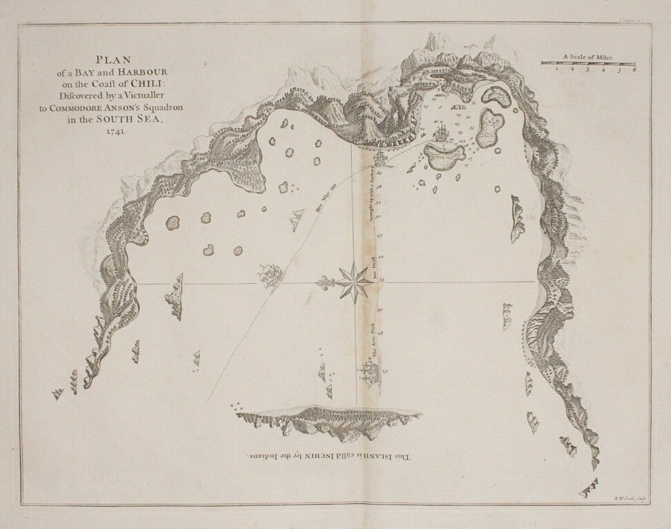
Plan of a bay and harbour on the coast of Chili € 50
A view of the north east side of Masa-Fuero lying in the latitude of 33*5' S*O € 70


A view of the west side of Masa-Fuero distant 4 miles € 50
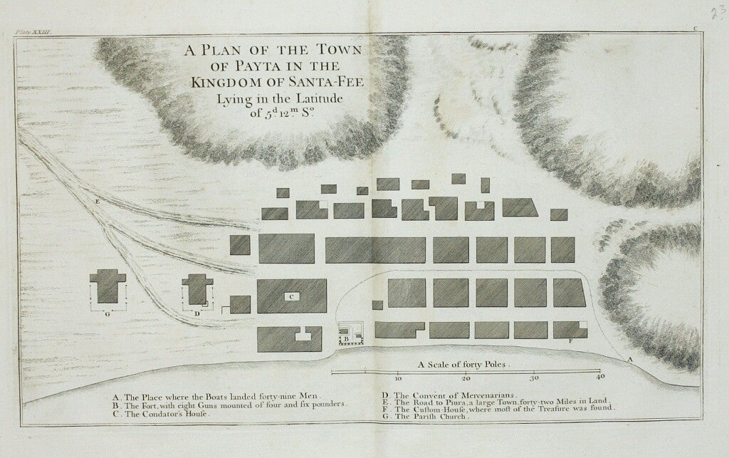
A plan of the town of Payta in the kingdom of Santa-Fee € 70
A plan of the east end of the island of Quibo € 50
The form of cruising off Acapulca on the coast of Mexico in the South Seas € 90
A view of the hill of Petaplan and the rocks called the White Friars, bearing SE. b E. distant 5 miles ; A view of the islands of Quibo and Quicara € 70


The bay and rocks of Petaplan € 50
A view of the entrance of Chequetan or Seguataneo bearing N. E. distant five miles € 50
A plan of the harbour of Chequetan or Seguataneo € 70
A view of the entrance of the port of Acapulco € 70
A view of the S W Site of Tenian € 70
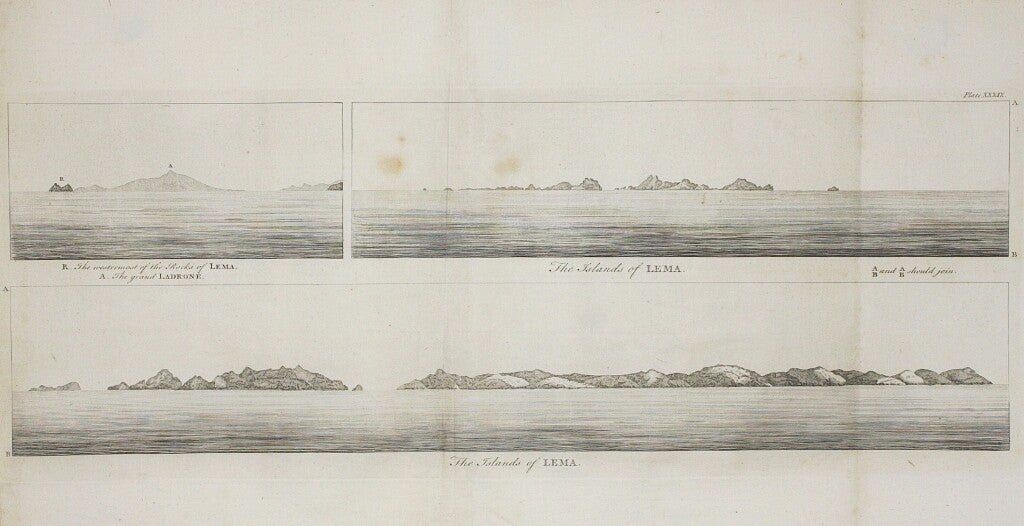
The islands of Lema € 50


A chart of the southern part of South America. Map 50x48 cm with ample margins. Folds as issued, uncoloured, verso blank. € 180
A chart of the Channel in the Phillipine Islands. Map 71x54 cm with ample margins. Folds as issued, uncoloured, verso blank. Some browning and offsetting. € 480
A chart of the Pacific Ocean from the Equinoctual. Map 88x28 cm on 2 jointed sheets. Folds as issued, uncoloured, verso blank. Moderate browning. € 250


Berckenrode, B. F. van
Ducatus Geldriae novissima descriptio
Amsterdam, engraved 1629, printed 1636
Map 46x55 cm, Centerfold as issued, hand colour, text on verso, repair in margin.
Regional map mainly of Gelderland and Utrecht compiled under the direction of Henricus Hondius (1597-1651) from the 1636 English language edition of the Mercator/Hondius Atlas, Or A Geographicke Description of the World. Unquestionably the most famous cartographer of all time, Gerard Mercator (1512-1594) envisioned his Atlas even before his friend Abraham Ortelius began work on his Theatrum, but it was late to publish, limited in geographic coverage, and never achieved commercial success in his lifetime or under the administration of his sons. However, with the addition of some 40 maps by the Hondius firm which purchased Mercator's plates from his heirs in 1604 an expanded and reissued "Mercator/Hondius" Atlas was published to great acclaim, eventually issued in nearly 50 editions in several languages. An scarce and important map.
€ 490


Bougainville, Hyacinthe-Yves-Philippe-Potentien, baron de
Paris, Arthus Bertrand 1837
From the rare atlas belonging to the “Journal de la navigation autour du globe de la frégate La Thétis et la corvette L’Espérance, executé pendant les années 1824, 1825 et 1826” with 56 plates, maps and plans, comprising 34 lithograph views and portraits after V. Adam, Sabatier and others from sketches by E.B. de la Touanne, printed by Bernard & Frey, 12 hand coloured engraved natural history plates after P. Bessa and J.-G. Pretre by Coutant, H. Legrand, Oudet, Dumenil and Massard, double-page hand coloured aquatint of various native vessels, folding engraved map, 2 double-page coastal profiles and 6 double-page engraved maps and charts, by A. Tardieu after E.B. de la Touanne. Some soiling and foxing in the margins, 52x65 cm, plates 46x60 cm, published 1837, maps dated 1828.
Idoles Chinoises de la Grande Pagode a Macao (une cloche,un tamtam de la même pagode)
Réception faite au Commandant Bougainville par les Mandarins de l'Empereur
Lithographic plate no. 4, thick paper ~28x20 cm on sheet ~52x34 cm. No fold, uncoloured, verso blank. Some foxing and browning in margins.
Bougainville only made a short visit to Macao, China.
€ 120
Lithographic plate no. 7, thick paper ~18x26 cm on sheet ~34x52 cm. No fold, uncoloured, verso blank. Some foxing and browning in margins, tear repaired with some damage in the plate (sky).
On January 12, 1825, the Thetis reached Tourane (Da Nang) Vietnam; In accordance with the instructions received, Bougainville tries to reconnect with the emperor of Annam Minh Mạng, mais les négociations s'avèrent difficiles en raison de l’absence du consul de France.
€ 80


Eléphant de Guerre de l'Empereur de Cochinchine / Interpréte des mandarins, Noix d'Arecet feuille de Betel, Couteau pour les préparer, et Bourse pour les contenir
Carte de la Partie de la Mer de la Chine / Carte de la Partie Septentrionale de l'Atoll Suadiva ( Iles Maldives ) / Carte d'une Partie des Iles Kangelang, Longue, Urck et Lombock
Lithographic plate no. 9, thick paper ~28x20 cm on sheet ~52x34 cm. No fold, uncoloured, verso blank. Some foxing and browning in margins.
Shows at the top a native of Cochinchina, Vietnam, and at the bottom an asiatic elephant.
€ 120
Map no. 47, thick paper ~60x49 cm on sheet ~65x52 cm. Centerfold as issued, uncoloured, verso blank. Brown stains in lower margin, mediocre copy. Rare.
Lithographic sea chart showing, on one sheet, two sea charts including several Islands of Indonesian Archipelago and a sea chart of Maldives.
€ 80


Carte d'une partie des Anambas
Plan du Port Clermont-Tonnerre Située à la partie Nord-Est des Iles Anambas Levé en 1825
Map no. 48, thick paper ~60x49 cm on sheet ~65x52 cm. Centerfold as issued, uncoloured, verso blank. Brown stains in left margin, mediocre copy. Rare.
Shows the Anambas archipelago, a small archipelago of Indonesia, located in the South China Sea between east and west Malaysia and Kalimantan. The island group is part of the Riau Islands Province. Depicts the route of the French ships Thetis and Esperance.
€ 80
Map no. 49, thick paper ~51x45 cm on sheet ~65x52 cm. Centerfold as issued, uncoloured, verso blank. Brown stains in left margin, mediocre copy. Rare.
Lithographic sea chart of Tuamotus or the Tuamotu Archipelago, a chain of atolls in French Polynesia and the largest chain of atolls in the world, spanning an area of the Pacific Ocean roughly the size of Western Europe. Map includes also the Bougainville Island, the main island of the Autonomous Region of Bougainville, part of Papua New Guinea.
€ 80


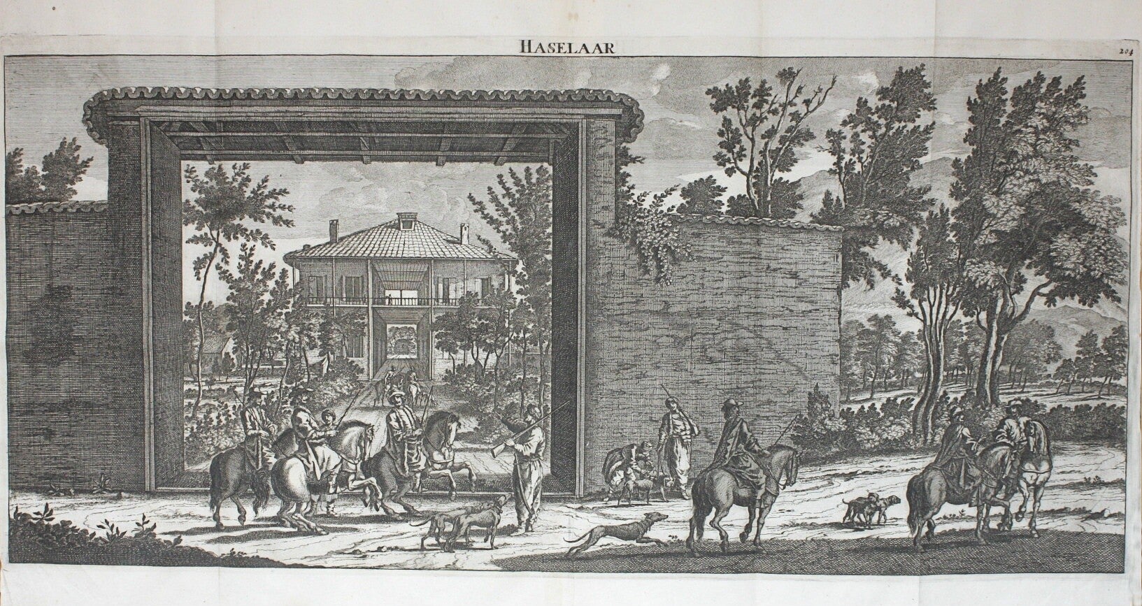
Bruyn, Cornelis de
Haselaar
Delft, Hendrik van Kroonevelt 1698
Large engraving and etching by Jan Luyken 1698, ~30x63 cm on sheet ~39x64 cm. Folds as issued, uncoloured, verso blank. Very good dark impression.
View of the hunting lodge of the Dutch merchants in Smyrna. In the foreground a group of hunters, six of them on horseback. Published in “Reizen van Cornelis de Bruyn, door de vermaardste deelen van Klein Asia”. Delft, Hendrik van Kroonevelt, 1698, page 391.
€ 160
Route Exacte de Gamron a Batavia et De Batavia a Gamron
Delft, Hendrik van Kroonevelt 1698
Map 23,5x30,5 cm on sheet 34,5x40,5 cm. Fold as issued, coloured, verso blank. Very good.
Published in Cornelis de Bruyn (Le Brun) “Voyages Par Le Muscovie, En Perse, Et Aux Indes Orientales” Amsterdam 1718. De Bruyn, a Dutch artist, began his epic journey to Moscow, Persia and the East Indies in 1701 at the age of 50. He spent most of 1703-04 in Persia and then travelled to Java in 1706. This map depicts the route from Gamron (modern Bandar Abas) to Batavia (Jakarta).
€ 270

Bry, J. Th. de
Bantam
~ 1600
Copper engraving ~1600, c15x25 cm. on sheet 18,5x28 cm. Small marginal repair, otherwise very good. No fold as issued, uncoloured. Verso blank.
This map of Bantam was first published in Willem Lodewijcksz' "t'Eerste boeck. Historie van Indien, waer inne verhaelt is de avonturen die de Hollantse schepen bejegent zijn" recounting the first voyage of Cornelis de Houtman, published by Cornelis Claesz in 1598. Re-engraving by De Bry for the third part of his Indiae orientalis navigationes.
€ 350

Quae ratio conditiove portuum et navium stationis as civitatem Bantam insulasque
~ 1600
Copper engraving ~1600, ~13,5x17,5 cm on sheet 31x19,5 cm. Very good. No fold as issued, uncoloured. Verso blank.
This map of the harbour of Bantam with Dutch ships was first published in Willem Lodewijcksz' "t'Eerste boeck. Historie van Indien, waer inne verhaelt is de avonturen die de Hollantse schepen bejegent zijn" recounting the first voyage of Cornelis de Houtman, published by Cornelis Claesz in 1598. Re-engraving by De Bry for the third part of his Indiae orientalis navigationes.
€ 190

Quo pacto nos ad reversionem in Hollandiam preparavimus
1601
Copper engraving with text 1601, ~14x17,5 cm on sheet 28,5x19,5 cm. Little browned and soiled, small stain in plate, otherwise very good. No fold as issued, uncoloured. Verso blank.
This engraving, depicting ship building for the voyage back home, was first published in Gerrit de Veer “Waerachtighe beschryvinghe van drie seylagien, ter werelt noyt soo vreemt ghehoort” mainly recounting the famous third voyage of Willem Barentsz, published by Cornelis Claesz in 1598. Re-engraving by De Bry for the third part of his Indiae orientalis navigationes.
€ 150

Navigationes nostrae principium
1601
Copper engraving with text 1601, ~13,5x17,5 cm on sheet 28,5x19,5 cm. Little browned and soiled, otherwise very good. No fold as issued, uncoloured. Verso blank.
This engraving, depicting the beginning of the voyage back home, was first published in Gerrit de Veer “Waerachtighe beschryvinghe van drie seylagien, ter werelt noyt soo vreemt ghehoort” mainly recounting the famous third voyage of Willem Barentsz, published by Cornelis Claesz in 1598. Re-engraving by De Bry for the third part of his Indiae orientalis navigationes.
€ 150

Cook, Captain James
Carte des Découvertes faites dans la Mer Pacifique sur la Vaisseau de Roi, La Resolution, Commandé par le Capitaine Cook en 1774
Paris, La Harpe 1785
Map on thick paper ~36x48 cm on sheet ~40x54 cm. Folds as issued, later colouring, verso blank. Nice copy.
Chart based on Cook’s second voyage, published in Paris 1785 by La Harpe and drawn by Benard, detailing the 1774 voyage of Captain Cook in the Pacific, showing the track and dates of the Resolution near New Caledonia and New Hebrides.
€ 190

Queen Charlotte’s Islands
London, Alexander Hogg [1784-1786]
Map ~22x34 cm on sheet ~24x39 cm. No fold, later colouring, verso blank.
Published in Anderson “A New, Authentic, and Complete Collection of Voyages around the World”, London, Alexander Hogg [1784-86]. The map features the sea-track of the Swallow commanded by Captain Carteret in 1767. The islands are now called the Solomon Islands.
€ 90

Three views of the Admiralty Isles
London, Alexander Hogg [1784-1786]
Map ~22x34 cm on sheet ~24x39 cm. No fold, later colouring, verso blank.
Published in Anderson “A New, Authentic, and Complete Collection of Voyages around the World”, London, Alexander Hogg [1784-86]. Coastal views of the Admiralty Island sighted by Carteret in September to October 1767 on his first voyage of the Pacific. The Admiralty Islands are an archipelago group of 18 islands in the Bismarck Archipelago, to the north of New Guinea in the South Pacific Ocean. First visitors of the islands were Saavedra in 1528 and Willem Schouten in 1616.
€ 60

Landing op het eiland Erramanga, een van de Nieuwe Hebriden
Leyden, Amsterdam & 's Haage, Honkoop, Allart & Van Cleef 1795-1809
Engraving ~1795, thick paper 20,5x45 cm on sheet 27x49 cm. Folds as issued, uncoloured, verso blank. Very good, a little age toning.
Plate LV of the Dutch edition of Captain Cook’s three voyages “Reize rondom de Waereld”. After the original drawing by Hodges, who was appointed by the Admiralty to record the places discovered on Cook's second voyage, undertaken in the 'Resolution' and 'Adventure', 1772-75.
€ 130

Poulaho, koning der Vrienden Eilanden / Eene vrouw van Eaoo / Vrouw van het eiland Tanna
Leyden, Amsterdam & 's Haage, Honkoop, Allart & Van Cleef 1795-1809
3 engravings on sheet 23x15 cm. No folds, uncoloured, verso blank.
From the Dutch edition of Captain Cook’s three voyages “Reize rondom de Waereld”.
The first two engravings after a drawing by John Webber come from Cook's third voyage. The woman of Tanna is from the second voyage, after the original drawing by Hodges.
€ 120 set


Bladeren en bloemen van de Barringtonia / Gereedschap van de inwooneren van de Nieuwe Hebriden / Wapenen en gereedschap van de inwooneren van Nieuw-Caledonia
Leyden, Amsterdam & 's Haage, Honkoop, Allart & Van Cleef 1795-1809
3 engravings on sheet 23x15 cm. No folds, uncoloured, verso blank.
From the Dutch edition of Captain Cook’s three voyages “Reize rondom de Waereld”.
After the original drawings by Hodges, who was appointed by the Admiralty to record the places discovered on Cook's second voyage, undertaken in the 'Resolution' and 'Adventure', 1772-75.
€ 100 set


Hawkesworth, John (after)
Charte von einem Theile des Süd-Meeres darinnen die verschiedenen Farthen und Entdeckungen angezeiget sind
~1780
“welche von nachstehenden Engl. Schiffen gemacht worden sind. Der Delphin vom Commodore Byron und die Tamar vom Capn. Mouat 1765, der Delphin vom Capn. Wallis und die Swallow von Capn. Carteret 1767 und der Endeavour vom Lieutenant Cook 1769 comandirt.”
Map 24x44,5 cm on sheet 27,5x46 cm. ~ 1780. Folds as issued, uncoloured, verso blank. Traces of use, Good only.
Rare variant, engraver T. A. Pringeling, of the German version of this famous map published in Campe’s Reisen, derived from John Hawkesworth's landmark "An Account of the Voyages Undertaken by the Order of his Present Majesty for Making Discoveries int he Southern Hemisphere".
€ 270

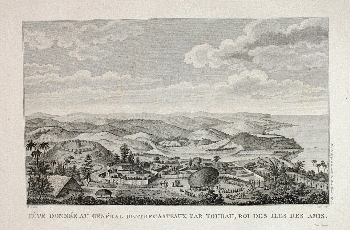
Labillardière, Jacques-Julien Houton de
Fête donnée au Général d'Entrecasteaux par Toubau, Roi des îles des Amis
Paris, H. J. Jansen An VIII [1800]
Dance des îles des Amis, en presence de la Reine Tiné
Paris, H. J. Jansen An VIII [1800]
Large copper engraving, 30x44 cm on sheet 43x57 cm. No folds, uncoloured, verso blank. Small, hardly visible, repair in plate.
From the “Atlas pour servir a la Relation du Voyage a la Recherche de La Perouse”, Paris, H.J. Jansen An VIII [1800].
€ 180

La Perouse, Jean François de Galaup
Plan des Iles Kuriles et des terres peu connues situees a la suite de ces Iles
Paris, L'Imprimerie de la Republique 1797
“d'apres au manuscrit conserve dans les Archives d'Ochotsk qui a ete communique a M. Lesseps, en 1788”
Map on thick paper, ~70x50 cm on sheet ~78x55 cm. Folds as issued, old colouring, verso blank. (Water) staining from margins into the plate. Scarce.
From the Atlas Du Voyage De La Pérouse nr. 69. Paris, L'Imprimerie de la Republique 1797.
€ 140

Plan de la Baie d'Estaing
Paris, L'Imprimerie de la Republique 1797
“Situee a la cote de l'ouest de Tchoka par 48°59'38" de Latitude Nord, et par 14°00'42" de Longitude Orientale, Prise du Mouillage de l'Astrolabe. Cette Baie fut decouverte le 20 juillet 1787 par les Fregates Francaises la Boussole et l'Astrolabe commandees par MM. de La Perouse et de Langle.”
Map on thick paper ~49x33 cm on sheet ~56x41 cm. No fold as issued, uncoloured, verso blank.
From the Atlas Du Voyage De La Pérouse nr. 51. Paris, L'Imprimerie de la Republique 1797.
€ 90

Plan de la Baie de Ternai
Paris, L'Imprimerie de la Republique 1797
“Située sur la Cote de Tartarie par 45°13'00" de Latitude Nord et par 135°09'00" de Longitude Orientale. Cette Baie fut decouverte le 22. Juin 1787, par les Fregates Francaises la Boussole et l'Astrolabe.”
Map on thick paper ~49x33 cm on sheet ~56x41 cm. No fold as issued, uncoloured, verso blank.
From the Atlas Du Voyage De La Pérouse nr. 48. Paris, L'Imprimerie de la Republique 1797.
€ 90

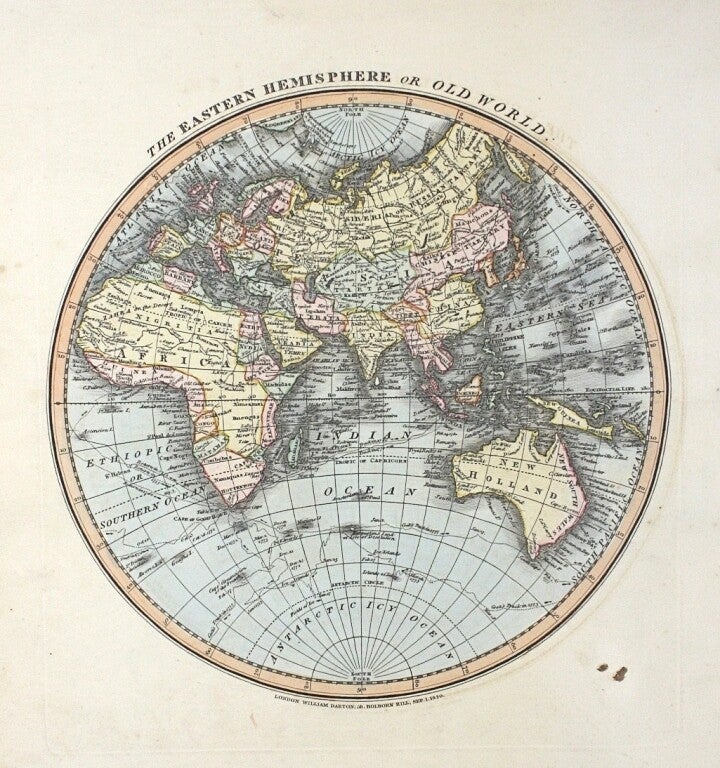
Laurie & Whittle
North Pole
South Pole
The eastern hemisphere or old world
London 1810
Each map on sheet 33x26 cm, no fold, original hand colouring, verso blank, very good condition. 1810. Scarce.
Maps show the tracks of Captain Cook and La Perouse. From their "New and accurate general atlas", published in London 1810. Laurie & Whittle were leading map publishers in London at the end of the 18th century.
€ 230 each


Meissas, Achile / Michelot, Auguste
Afrique
Paris, Hachette 1840
Large steel engraved map ~38x48 cm on sheet 44x56,5 cm. Centerfold as issued, original outline hand colouring, verso blank. Two tiny holes, Scarce.
From the Atlas universel de géographie moderne. Paris, Hachette, map dated 1840 in cartouche.
€ 90

Oceanie
Paris, Hachette 1840
Large steel engraved map ~32x45 cm on sheet 41x55 cm. Centerfold as issued, original outline hand colouring, verso blank. Scarce.
From the Atlas universel de géographie moderne. Paris, Hachette, map dated 1840 in cartouche.
€ 90

Moll, Herman
Negroland and Guinea with the European Settlements, Explaining what belongs to England, Holland, Denmark, etc
London, Thomas and John Bowles 1728
Map, dated in cartouche 1728, 20x27,5 cm on sheet 22x32 cm. No fold, coloured, verso blank. Scarce.
Herman Moll's map from the Atlas Minor (London, Thomas and John Bowles) labels the "Grain Coast", "Slave Coast", and "Gold Coast". Negroland was the territory to the north of this, along the east–west axis of the Niger River, and the west-facing coast. Moll's map labels Gambia, Senegal, Mandinga, and many other territories.
€ 170

Munster, Sebastian
Stagno meridionale - Della Germania (Friesland, Drente, Overijssel)
~1558
Map 19,5x15,5 cm. ~1558. Woodblock map, no fold, uncoloured. Slight damp stains in margins. Nice frame, back side with glass showing verso text page.
The Provinces of Friesland, Drente and Overijssel with the major cities located. Two coats of arms are incorporated into the map. Latin text below and on verso with three woodblock illustrations, including a battle scene.
€ 230


Pallas, Peter Simon
Vorstellung der Gegend längst dem Sok Fluss, von dessen Ursprung bis Sergiefskoi Prigorod
St. Petersburg 1771-1776
Map 32x36 cm on sheet 38x42 cm. Folds as issued, old hand colouring, little damp in margins. Rare.
Published in “Reise durch verschiedene Provinzen des Russischen Reichs ” St. Petersburg 1771-1776.
€ 190

Carte des Monts Altaisk et des Deserts salins qui avoisinent
St. Petersburg 1771-1776
Map, engraver Tardieu, 29x44,5 cm on sheet 36x50 cm. Folds as issued, light offsetting, little damp in margins, uncoloured. Rare.
Published in “Voyages de M. P. S. Pallas en differentes provinces de l'empire de Russie, et dans l'Asie septentrionale” Paris 1788-1793.
€ 150

Phillip, Arthur
A Chart of a Track of Land in the Southern Pacific Ocean, Discovered by Lieutt. John Shortland
London, John Stockdale 1789
“on His Homeward bound Passage from the Eastern Coast of New South Wales by Thomas Geor. Shortland of the Royal Navy, August 20th, 1789”
Map ~33x37 cm on sheet ~39x39 cm. Folds as issued, uncoloured, verso blank.
Published in the first edition of Arthur Phillip “The voyage of Governor Phillip to Botany Bay; with an account of the establishment of Port Jackson & Norfolk Island”. London, John Stockdale, 1789. Coastal map of New Georgia, Solomon Islands, with locations of fresh water and relief shown by bathymetric soundings. New Georgia is the largest island of the Western Province of the Solomon Islands. Captain John Shortland was the person in the Navy who organized many of the details for the First Fleet which took the first convicts to Australia in 1788. He arranged for two of his sons, John and Thomas George Shortland, to sail with him on the First Fleet.
€ 150

Prevost d'Exiles / Bellin, Jacques Nicolas
Paris 1746-1761
The maps come from the original French edition of Prevost “Histoire générale des Voyages, ou nouvelle Collection de toutes les Relations de Voyages par Mer et par Terre”, published Paris 1746-1761. Bellin, who designed the maps, was one of the important French mapmakers of that century.
Carte Des Pais Habites par Les Samojedes Et Ostiacs
Paris 1757
Map 1757, 16x24 cm on sheet 25x29 cm. Fold as issued, later colouring, verso blank.
The map shows Nova Zembla and the coast of northern Russia.
€ 100

Carte du Détroit de Waeigats ou de Nassou suivant les navigateurs Hollandois
Paris 1758
Map 1758, 20x30 cm on sheet 25x37 cm. Fold as issued, uncoloured, verso blank.
Shows the Strait of Waeigats in the Arctic Sea and the “Route des Hollandois en 1594”, the voyage of Willem Barentsz.
€ 100

Carte De La Coste Occidentale D'Afrique
Paris 1754
Map 1754, 20x25 cm on sheet 25x29 cm. Fold as issued, later colouring, verso blank.
Shows a part of the West African slavery coast, indicating the English, Dutch and French possessions.
€ 120

Carte du Kamtchatka
Paris 1757
Map -drawn and engraved by J. Laurent- 1757, 51x29 cm on sheet 56x35 cm. Folds as issued, later colouring, verso blank. Apart from a small closed tear a very good copy.
Depicts Kamtchatcka, Kourile Islands and parts of the Sea of Okhotsk and the Bering Sea. With Vitus Bering's Second Kamchatka Expedition (ca 1733–1743), in the service of the Russian Navy, began the final "opening" of Kamchatka.
€ 230

Fort Hollandois de Paliacate nommé le Fort de Gueldre
Paris 1751
Copper engraving 1751, 19,5x14 cm on sheet 29x21 cm. No folds, uncoloured, verso blank. Excellent condition.
Dutch fort on the coast of Coromandel.
€ 70

Sanson, Nicolas
La Guinee et Pays Circomvoisins; Tires de Mercator, de Blommart
~1680
Map ~1680, 16,5x30,5 cm on sheet 22x35 cm. Folds as issued, coloured, verso blank.
Interesting early map of the Slave Coast, of which are several editions. Nicolas Sanson (1600 – 1667) was a French cartographer, termed by some the creator of French geography, in which he's been called the father of French cartography.
€ 180

Schraembl, Franz Anton
Karte von den N.W. Amerikanischen und N.OE. Asiatischen Kusten nach den Untersuchungen des Kapit. Cook in den Jah. 1778 und 1779
1788
Very large map ~39x68 cm on sheet ~63x78 cm. No folds as issued, outline coloured, verso blank. Borders of sheet frayed, otherwise very good. Scarce.
From the “Allgemeiner Grosser Atlas” 1788. Rare German language variant of Cook’s map of his explorations along the northwest coast of America and the northeast coast of Asia. Based upon original work by Cook’s cartographer Henry Roberts. Depicts much of Siberia and Kamtschaka in Asia and, in America, shows Canada as far east as the western portions of Hudson Bay. Alaska and Asia are shown with considerable accuracy though Vancouver Island is missing.
€ 480

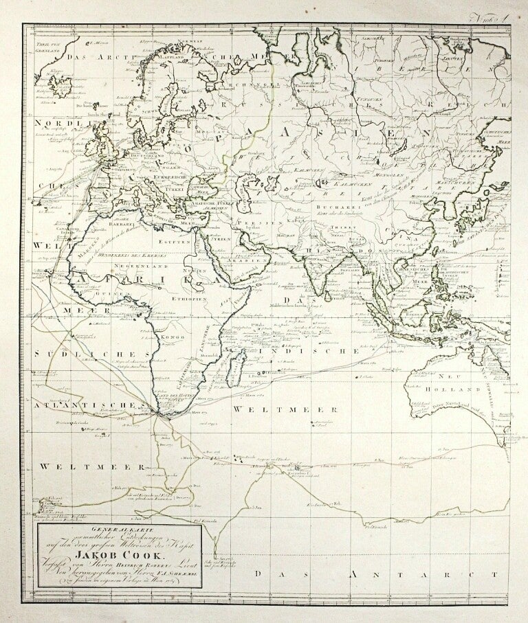
Generalkarte sämmtlicher Entdeckungen auf den drei großen Weltreisen des Kapit. Jakob Cook
1788
2 large maps ~53x44 cm on sheet ~87x64 cm, to be conjoined (or not). No folds as issued, outline coloured, verso blank. Borders of sheets a bit frayed, back of left map partly slightly discoloured, but not showing through. Otherwise very good. Rare complete set.
From the “Allgemeiner Grosser Atlas” 1788. Rare early German language variant of Cook’s map of his three voyages of discovery on two double-page engraved sheets.
€ 980 set

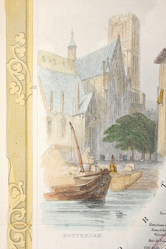
Tallis, John
Holland
1851
Map 34x24 cm, 1851. Centerfold as issued. Original outline and later wash hand colouring to the vignettes.
The John Tallis company were prominent publishers in the mid-nineteenth century but are best known for producing "the last great decorative world atlas" when they issued 'The Illustrated Atlas' in 1851. This map, drawn by J. Rapkin has fine detail and includes the cities of Amsterdam, Utrecht, Arnhem, The Hague, and Groningen. There are three attractive vignettes: 'Rotterdam', 'On the Dort', and 'Dutch Peasants'. The map has a nice decorative border.
€ 140

Tirion, Isaak
Nuova carta della contea di Olanda
1742
Map 27x32 cm in frame 37x47 cm, folds as issued, old hand colouring, verso blank.
Published in "Storia Moderna, ovvero Lo Stato presente di tutti i Popoli del Mondo". Giambatasta Albrizzi. Venezia 1742, based on a map by De l’Isle. (Blonk nr. 85).
€ 190
The same, on sheet 38x49,5 cm. Centerfold, uncoloured, verso blank.
€ 140


Valentyn, Francois
Frontispiece from “Oud en nieuw Oost-Indiën”
1724/1726
Caarte … Samarang
1724/1726
Engraving 1724/1726 on sheet 34x20,5 cm. No folds, uncoloured, verso blank. Very good condition, small left margin.
€ 190
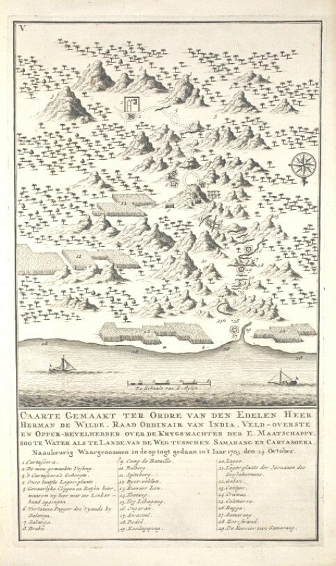
“Caarte Gemaakt ter Ordre van den Edelen Heer herman de Wilde, Raad Ordinair van India, Veld-overste en Opper-bevelhebber over de Krygsmachten der E. Maatschappy, soo te Water als te Lande, van de Weg tusschen Samarang en Cartasoera, Naaukeurig Waargenoomen in de opt togt gedaan in 't Iaar 1705 den 24. October”.
Engraving 1724/1726 on sheet 34,5x21 cm. No folds, uncoloured, verso blank. Very good.
Part IV-I, after page 148.
€ 80

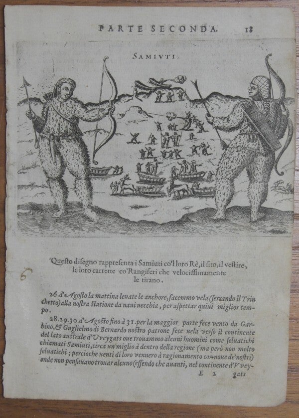
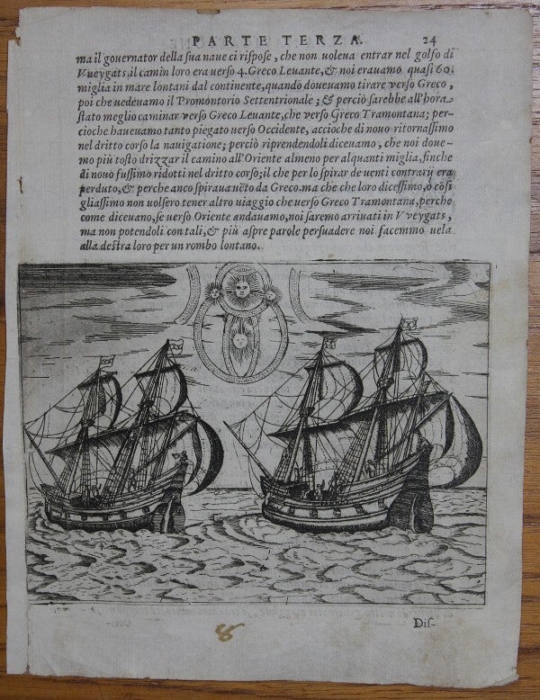
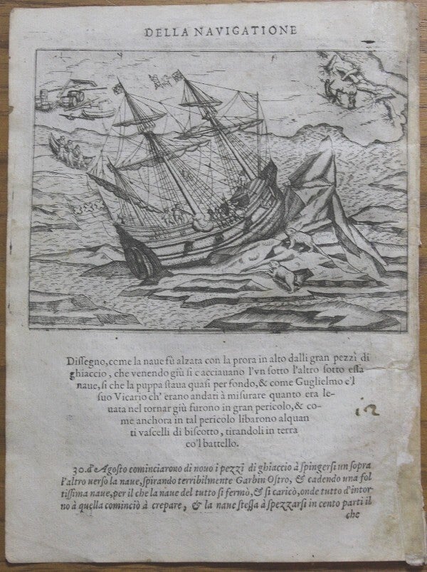
Veer, Gerrit de
Tre navigationi fatte dagli Olandesi, e Zelandesi al settentrione nella Norvegia, Moscovia, e Tartaria
Venice, (G. B. Ciotti für) G. Porro u. Co 1599 first Italian edition (second imprint)
Original iconic engravings, appr. 10x14 cm, on a leaf with Italian text from the first Italian edition of "Waerachtighe beschryvinghe van drie seylagien" 1598.
This work contains an account of three early Dutch voyages for the discovery of the North East passage to China and Cathay, and contains valuable early particulars regarding Nova Zembla and Northern Siberia. The famous Dutchman William Barentsz sailed along that coast and various other Dutch expeditions sought to discover a new route to the East Indies by way of the North-East Passage.
Map of Nova Zembla
Collision between the ships of Barentsz and Van Linschoten
Map of arrival of the 7 ships at Nova Zembla and Waygat
Samoyedic people
Age wear and toning, contemporary handwriting, cropped and minor flaws. € 200
Age wear and toning, contemporary handwriting, cropped and minor flaws. € 120
Age wear and toning, contemporary handwriting, cropped, back of left side strenghtened and minor flaws. € 200
Age wear and toning, contemporary handwriting, cropped and minor flaws. € 80


Shooting a polar bear
Two ships and a celestial phenomenon
Fight with a polar bear
Ship of Barentsz near Orange islands
Age wear and toning, contemporary handwriting, cropped, back of left side strenghtened and minor flaws. € 120
Age wear and toning, contemporary handwriting, cropped, back of left side strenghtened and minor flaws. € 100
Age wear and toning, contemporary handwriting, cropped, right side partly strenghtened and minor flaws. € 120
Age wear and toning, contemporary handwriting, cropped and minor flaws. € 140


Ship getting stuck in ice
Ship stuck in ice
Crew fighting with a polar bear
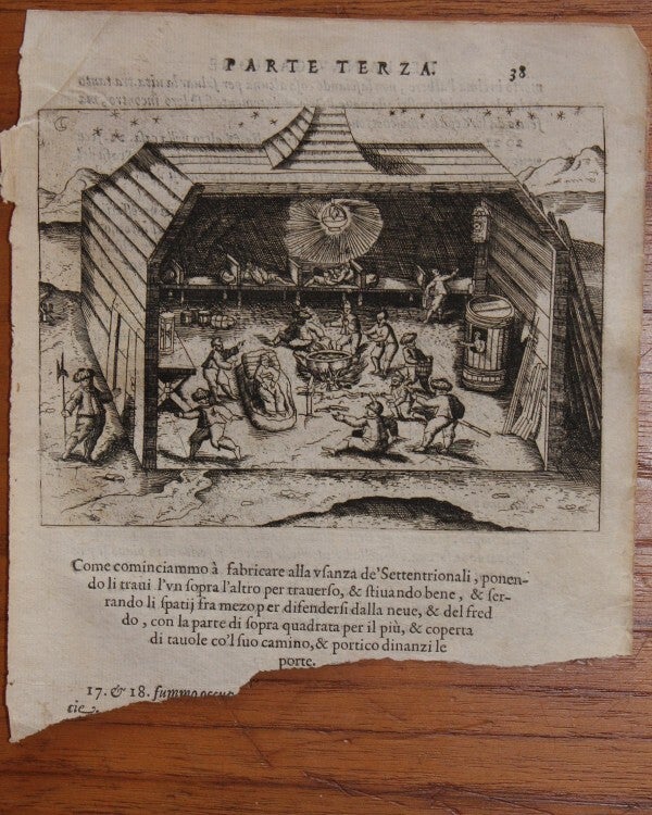
Behouden huys: building activity
Age wear and toning, contemporary handwriting, cropped, right side partly strenghtened and minor flaws. € 120
Age wear and toning, contemporary handwriting, cropped, back of left side strenghtened and minor flaws. € 120
Age wear and toning, contemporary handwriting and minor flaws. € 140
Age wear and toning, contemporary handwriting, back of left side strenghtened and minor loss in left border. € 120


Behouden huys: interior
Attacked by polar bears near Behouden huys
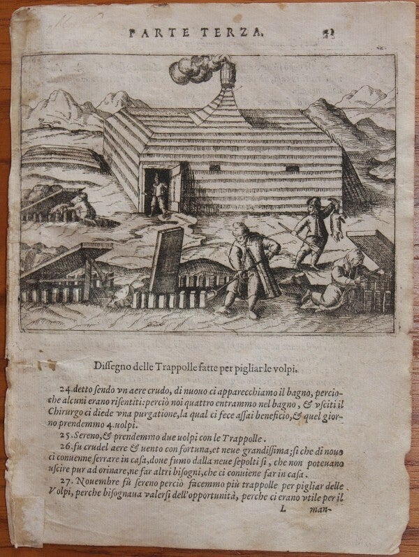
Checking fox traps near Behouden huys
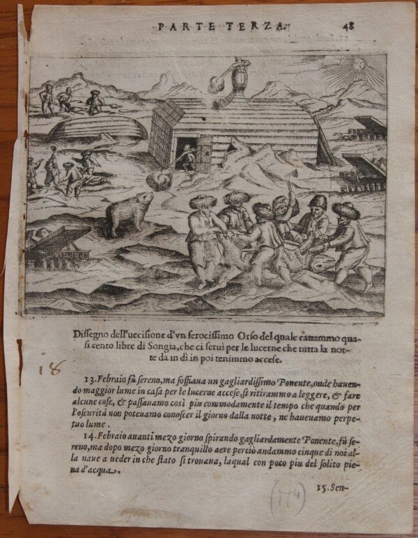
Shooting and skinning a polar bear near Behouden huys
Age wear and toning, lacks lower part of leaf, minor flaws. € 190
Age wear and toning, small loss in left border and minor flaws. € 70
Age wear and toning, contemporary handwriting, back of left side strenghtened and minor flaws. € 130
Age wear and toning, contemporary handwriting, cropped and minor flaws. € 120

Carpentry sloop near Behouden huys
Sloops are launched
Sloops are unloaded
Age wear and toning, damage to image upper right and minor flaws. € 50
Age wear and toning, contemporary handwriting, cropped and minor flaws. € 120
Age wear and toning, contemporary handwriting, cropped, back of left side strenghtened and minor flaws. € 80


Ship Barentsz near Orange island
Sloops in dangerous ice
Punishment excercise
Age wear and toning, contemporary handwriting, cropped, back of left side strenghtened and minor flaws. € 120
Age wear and toning, contemporary handwriting and minor flaws. € 130
Age wear and toning, contemporary handwriting, cropped, back of left side strenghtened and minor flaws. € 100


Meeting and trading with Russians in sloops
Map of the Russian coast with Cola and Kilduin island
Map of island Kilduin near the Russian coast
Age wear and toning, contemporary handwriting, cropped, back of right side strenghtened and minor flaws. € 120
Age wear and toning, contemporary handwriting, cropped, left border repaired with minor loss, minor flaws. € 120
Age wear and toning, contemporary handwriting, cropped and minor flaws. € 160


Visscher, N.
Ducatus Geldriae et Zutphaniae Comitatus
~1680
Map 45x55 cm, ~1680, published in Amsterdam. Centerfold as issued, old colouring. Light soiling in margins.
Probably from one of the great W. Blaeu Atlas Maior editions of the late 17th century (post-1662). Visscher cited as draughtsman in the lower right corner. Map of the Dutch provinces of Gelderland and Noord Brabant. Showing the Zuyder Zee, Zwolle, Wesel, Eindhoven and Utrecht. North orientated to the right. Decorative cartouche and scale of miles with coat of arms and cherubs.
€ 390


Novissima Comitatus Zutphaniae totiusque fluminis Isulae descriptio
~1700
Map 52x62 cm, ~1700 by P. Schenk jr. Centerfold as issued, old outline colouring, recent frame.
Graafschap Zutphen with bottom left title cartouche with putti and publisher's imprint. Bottom right cartouche with putti, weapon and distant scales.
€ 480


Wit, Frederick de
Novissima et accuratissima XVII Provinciarum
1680
Map 50x56 cm, 1680, Centerfold (misfolding) as issued, old colouring, unobtrusive blind stamp in plate, little soiling, recent framing.
Map of the XVII Provinces with the west on top. Decorative cartouche topped with a rampant lion with a sword. At the bottom of the cartouche there is the crest of Johan Munter. Munter was a wealthy merchant in Amsterdam and member of the governing body of the V.O.C. and finally became major of the city. This second state was published by Frederick De Wit in the 1680 edition of Atlas Major. The first state was published in 1672. De Wit was one of the most prominent and successful map engravers and publishers in Amsterdam in the period following the decline of the Blaeu and Jansson establishments, from which he acquired many copper plates when they were dispersed at auction.
€ 690

